


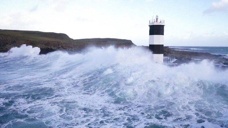
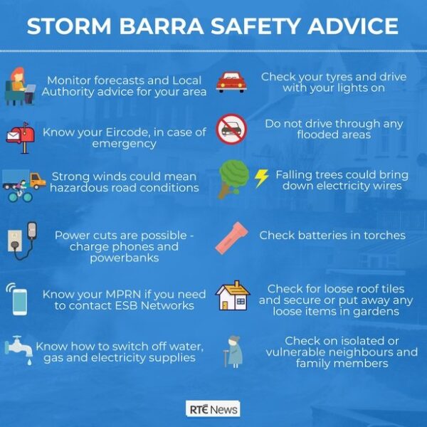
Coastal areas across the UK are braced for the impact of Storm Barra later, while a rare red alert has been issued in the Republic of Ireland.
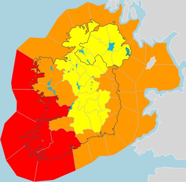
The highest level of Irish weather service Met Éireann’s warning affects counties Clare, Cork and Kerry, and schools are to close in 12 counties.
It warns of severe and damaging gusts of more than 130km/h (80mph).
Disruptive wind and some snow are expected in parts of northern England and Scotland, said the Met Office.
Some flights have been cancelled, driving conditions are set to be difficult and there are fears of damage to buildings, power cuts and flooding.
The second named storm this season, Storm Barra comes just 10 days after Storm Arwen struck on 26 November, causing disruption and three fatalities across the UK.
Wave warnings
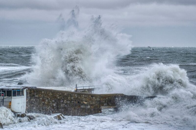
Met Éireann has warned Storm Barra will likely cause coastal flooding along parts of the south and western Irish coast, while disruption to power and travel is also likely.
With a status orange warning – the second-highest level – in place for Clare, Limerick and Galway, and a yellow warning for all other counties, it has urged people to take action to protect themselves and their homes.
A cold start with some icy stretches #Tuesday morning 📉🌡️ #StormBarra quickly arrives from the west with heavy rain and gales for most, severe gales and snow for some🌧️🌧️❄️🌬️🌬️
Weather warnings are in place⚠️
Stay #WeatherAware pic.twitter.com/xWqm7LNzGH— Met Office (@metoffice) December 6, 2021
A Met Office yellow warning for Northern Ireland has been issued from 06:00 GMT on Tuesday to 09:00 on Wednesday.
The strongest gusts will affect exposed and coastal areas, with potentially damaging and disruptive winds up to 80km/h (50mph) expected widely.
The Met Office says winds are likely to be strongest in the region along the coasts of counties Down and Antrim where large waves could cause disruption.
Gusts around the coast could reach speeds of 120km/h (75 mph).
Heavy and persistent rain on Tuesday morning will be followed by frequent and heavy showers into Wednesday.
Up to 30mm of rain is forecast quite widely, while higher ground could get as much as 50mm.
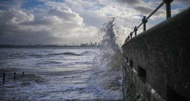
The Royal National Lifeboat Institution (RNLI) has appealed for people to stay well back from the water’s edge due to the risk of large waves, and in any coastal emergency to dial 999 for the coastguard.
Cancellations and closures
The Irish Department of Education has advised that all schools covered by an orange or red warning should shut on Tuesday – which covers 12 counties.
Schools in other areas should keep up-to-date with weather warnings for any changes, the department said.
University College Cork will also be closed as will the Covid-19 vaccination clinic at Cork City Hall.
An Garda Síochána (Irish police) are advising people to avoid all unnecessary travel where red and orange warnings are in place.
With the arrival of #StormBarra tomorrow, we continue to advise that all unnecessary travel should be avoided where Red and Orange warnings are in place
We advise the public to regularly monitor https://t.co/TJBfRQ159T for further updates over the next two days https://t.co/YPUJYgYoR8
— An Garda Síochána (@GardaTraffic) December 6, 2021
Flight operator Aer Lingus has already cancelled some early morning services on Tuesday, including flights from Cork to Amsterdam and London Heathrow.
Customers are advised to check with the airline for further information.
With #StormBarra on the way, 60-70mph gusts are expected in coastal locations. #RespectTheWater by staying well back from the water’s edge and in any coastal emergency dial 999 for the Coastguard. If you end up in the water, stay calm and #FloatToLive. pic.twitter.com/2mscNadUy8
— RNLI (@RNLI) December 6, 2021
Victoria Park in east Belfast will be closed from 06:00 GMT until 09:00 on Tuesday, Belfast City Council confirmed.
Some events have been cancelled too, including the Christmas market in Cork, planned for Tuesday at Macroom Town Square./BBC
Storm Barra: What areas will be worst hit and what is closing?
Q&A: Schools, hospitals and buses disrupted due to threat of severe winds in 12 counties
Just how serious is Storm Barra?
Storm Barra is set to hit Ireland fully on Tuesday morning, with Met Éireann warning that the severe weather could pose a threat to life.
The storm will rapidly deepen over the west and south coast on Monday evening, bringing very strong winds and heavy rain on Tuesday and into Wednesday.
Met Éireann have also warned that there is a risk of snow, as well as coastal flooding, due to the combination of high waves, storm surges and high tide.
Southwesterly winds, which will later veer northwesterly, will reach mean speeds in excess of 80 km/h.
Severe or damaging gusts may reach speeds in excess of 130km/h.
Power and travel may be disrupted across the country.
What are the areas most affected?
There is a status red wind warning in place for counties Cork, Kerry and Clare. Cork and Kerry’s warning starts at 6am on Tuesday and lasts until 9pm that evening.
Clare will be under a red alert from 4pm on Tuesday until 1am on Wednesday.
Limerick, Waterford, Galway, Mayo, Wexford, Dublin, Louth, Wicklow and Meath are also under an orange wind warning.
However, Met Éireann have advised that there is a strong possibility that the status orange alerts will escalate to status red.
A red marine storm warning will also be in effect for Irish coastal waters from north Mayo to Cork city.
The rest of the country will be under a status yellow wind and rain warning, with Met Éireann saying that heavy rain may result in surface flooding.
There is also a risk of snow over the entire country, and flooding in coastal areas.
Is it okay to go out in the storm?
People in the affected areas are being advised to avoid all unnecessary journeys, meaning you should stay indoors if possible.
People on motorbikes, cyclists, and pedestrians should take extra care if they have to travel, and they should avoid coastal areas.
Motorists are also advised to be more wary while driving, and to look out for fallen trees and debris on the road.
The charity Alone urged older people to take extra care and called on members of the public to “check in with their older neighbours and relatives and assist them if they need to travel to the local shop, post office or medical appointments during the bad weather”.
What has been cancelled or closed?
The Department of Education, which oversees primary and secondary schools, has advised schools in red and orange alert counties to close.
The Department of Higher Education, which governs colleges, universities and further education institutes, has issued a similar statement, saying education institutions in red and orange alert counties should close also.
Creches, early learning and school-age childcare services in the 12 counties should not open tomorrow, according to the Department of Children. Services that close will receive Force Majeure funding, according to the department.
Bus Éireann services in Co Cork and Co Kerry will be suspended for the full day. Services in Co Clare will be suspended from 4pm on Tuesday until 1am on Wednesday. This cancellation will also apply to all routes operating into or out of the status red warning area including Expressway Route 51.
Some hospital appointments have been cancelled, and Covid-19 testing and vaccination centres in status red and orange counties have also been forced to close due to the storm. A list of the affected health services can be found here. The National Ambulance Service will prioritise emergency calls during this weather event but is urging the general public to think carefully before calling 999/112.
The Courts Service has also confirmed that all sittings in red alert counties have been cancelled.
The Department of Local Government said a large number of national parks and reserves including Killarney National Park and Muckross House would close on Tuesday and Wednesday. Powerscourt Estate in Co Wicklow will close from 8am until 1pm on Tuesday.
Aldi has also said its stores in Cork and Kerry will be closed all day Tuesday, and their Clare stores will shut at 3pm on Tuesday.
Lidl and Tesco stores in Cork and Kerry will also be closed all day.
How long is the storm expected to last?
According to Met Éireann, Storm Barra will gradually clear Ireland later on Wednesday and winds will slowly ease, with a more settled few days to end the week./The Irish Times
Storm Barra – Red alert for Kerry, Cork and Clare as ‘weather bomb’ to hit
The Department of Education has advised that schools should not open tomorrow in 12 counties covered by Status Red and Orange weather warnings for Storm Barra.
The Red warning has been issued for Cork, Kerry and Clare tomorrow, while an Orange warning will be in place for many other counties around the country.
In a statement, the department said that Met Éireann has advised there is a strong possibility that the status of counties covered by the Orange level warning are likely to change and escalate to Status Red.
It offered similar advice to all universities, colleges and further education facilities in the affected areas.
Bus Éireann has announced that school transport services in the 12 counties covered by the Red and Orange warnings are also cancelled.
The HSE has said that there will be a disruption to some of its services tomorrow, including Covid-19 vaccination and test centres, due to Storm Barra.
The Head of Forecasting at Met Éireann Evelyn Cusack said that the storm is currently forming in the middle of the Atlantic Ocean and what could be described as a “weather bomb” is heading our way.
Speaking on RTÉ’s News at One, Ms Cusack said there is “a danger to life”, as well as a risk of snow and flooding, over the next two days.
Storm Barra will bring wind gusts in excess of 130km/h and Met Éireann said there is a risk of coastal flooding due to a combination of high waves, storm surge and high tide.
It said that power supplies and travel services are likely to be disrupted.
The Red warning for Cork and Kerry will be in effect from 6am to 9pm tomorrow, while it covers Clare from 4pm until 1am on Wednesday.
An Orange Weather warning will be in place in Limerick, Waterford, Wexford, Galway and Mayo, as well as Cork, Clare and Kerry.
A similar Orange warning will be in place for Dublin, Wicklow, Louth and east Meath from 8am to 1pm tomorrow.
A Yellow rain and wind warning is in place for the whole country from 2am to 6pm tomorrow.
The UK Met Office has also issued a Status Yellow wind warning for Northern Ireland and said strong winds are expected to affect most areas with the potential for travel disruption in places.
Meanwhile, a Status Red marine warning is also in place today on Irish coastal waters from Roche’s Point to Valentia to Erris Head, with Storm Force 11 winds expected.
Ms Cusack said Storm Barra is a multi-faceted weather system, which will last through tomorrow, tomorrow night and into Wednesday.
Tomorrow morning will see heavy rain and south easterly winds around the country.
She urged people to input their location into the Met Éireann app, which will give hourly forecasts as it will vary throughout the day.
Speaking earlier on RTÉ’s Today with Claire Byrne, Ms Cusack said the local authorities and emergency services are preparing for multiple hazards brought about by “a significant and severe weather event”.
She said the storm will being very heavy rainfalls of between 50mm and 70mm. Storm Barra will hit the west coast between 4am and 5am tomorrow morning and will quickly extend across the country.
Ms Cusack said it will be “a very bad morning everywhere” with very strong and gale-force southeasterly winds, accompanied by driving rain and snow in places.
She said there could be snow blizzards for a few hours in parts of Donegal, Sligo and the northwest.
Ms Cusack urged people to be very careful and to take preventative action today, such as tying everything down, bringing in outdoor furniture and securing Christmas decorations.
Parts of Galway, Limerick, and Tipperary will also experience very stormy conditions.
Ms Cusack said Storm Barra will result in quite dangerous driving conditions throughout tomorrow and up to midday on Wednesday.
Cork Airport has said that both early morning Aer Lingus flights to Amsterdam and London from the airport have been cancelled.
Aer Lingus is due to review the remainder of tomorrow’s schedule later this evening or early tomorrow.
Taoiseach Micheál Martin has said the Government is very, very concerned about Storm Barra and would urge people to stay at home unless it is necessary to travel.
He said this is a very, very serious storm and he urged people to stay away from coastlines.
Public urged to shelter in place
The head of the National Emergency Coordination Group has urged people in areas where a Red warning is in effect to seek shelter before the warning and to remain indoors until it expires.
Speaking on RTÉ’s News at One, Keith Leonard said this means no travel, no movement outside of buildings during Red level warnings.
He said in areas where an Orange Level warning is in place, people should only travel if necessary and motorists should be aware of the hazardous travel conditions, such as fallen trees and power lines.
As well as strong winds, #StormBarra will bring spells of heavy rain through tomorrow and Wednesday which could lead to surface flooding and tricky driving conditions.
⚠️Yellow #rain warning issued nationwide.
ℹ️https://t.co/XGJxZFd5UU pic.twitter.com/pNfr18wk0j
— Met Éireann (@MetEireann) December 6, 2021
Mr Leonard said the main response agencies have been preparing for this storm since Friday and have been activating the crisis management and local coordination teams.
They have begun deploying sandbags, erecting temporary flood defences and starting to ramp up the local communications and public safety messaging.
Mr Leonard urged people to stay away from coastal areas for the duration of the warnings and to keep their mobile phones charged in case they need to contact the emergency services.
He said Cork will experience some flooding, Galway city has deployed its aqua dam to try to mitigate the worst affects, but coastal flooding is expected across the country, including in Dublin city.
After a blustery day, #StormBarra will rapidly deepen this evening bringing very strong winds and heavy rain to Ireland tomorrow and Wednesday⚠️🍃☔️
Barra will gradually clear Ireland later on Wednesday and winds will slowly ease, with a more settled few days to end the week. pic.twitter.com/qJFzn8btKB
— Met Éireann (@MetEireann) December 6, 2021
The Coast Guard is appealing to all mariners and coastal communities to be mindful of the severe weather warnings.
The organisation is also appealing to anybody considering any form of coastal or open water recreation to be mindful of the risk posed by forecasted storm conditions.
Coast Guard Operations Manager Micheál O’Toole appealed to the public to remain vigilant and to avoid any unnecessary travel.
Disruption to health services in Cork and Kerry
The HSE has said that there will be disruption to hospital services across Cork and Kerry due to the impact of Storm Barra.
In a statement, it says that appointments may be cancelled as the focus will be kept on keeping essential and life-saving services available.
In terms of hospital services, the HSE says that the South/South West Hospital Group is advising that all elective inpatient and outpatient appointments and procedures in Cork University Hospital, Bantry General Hospital, Mallow General Hospital, Mercy University Hospital, South Infirmary Victoria University Hospital and University Hospital Kerry are cancelled tomorrow with the exception of time critical cases.
The HSE says that the appointments will be rescheduled as soon as possible.
All Covid-19 vaccination and test centres in Cork and Kerry will be closed tomorrow and appointments will be rescheduled. Community services, such as day services, will also be closed tomorrow.
The HSE says that there will be no Covid-19 testing carried out at centres in Ennis, Co Clare, Nenagh, Co Tipperary and the centre on the Ballysimon Road in Limerick.
Meanwhile, court sittings in Kerry, Cork, Clare and Newcastle West have also been cancelled.
Separately, the Department of Children has advised all early learning and care and school-age childcare services covered by the Red and Orange warnings should not open tomorrow.
Councils preparing for potential damage ahead of storm
Cork City Council has issued a warning to city centre residents and traders about the possibility of flooding along the city quays on foot of a predicted tidal surge.
Kerry County Council said that its Severe Weather Coordination Team, including representatives from Kerry County Council, An Garda Síochána, the HSE, Kerry Fire Service and Kerry Civil Defence is meeting this afternoon to coordinate a response to Storm Barra.
It said that members of the public are advised to remain indoors and to avoid travel for the duration of the weather warning.
Limerick City and County Council has been installing flood defences along the estuary and city quays.
Flood defences are being installed at vulnerable locations in Askeaton and Foynes, while the flood barriers on the city quays along the Three Bridges route are being put in place.
Clare County Council has advised business owners, caravan parks, homeowners and members of the public that caravans should be securely tied down and any street furniture, including parasols and awnings, should be taken indoors or fully secured.
Meanwhile, Dublin City Council has said it is closing the car parks at Clontarf and Sandymount, as well as the flood gates along the Dodder.
It has also urged people to avoid the sea and coastal areas during the storm./RTÉ
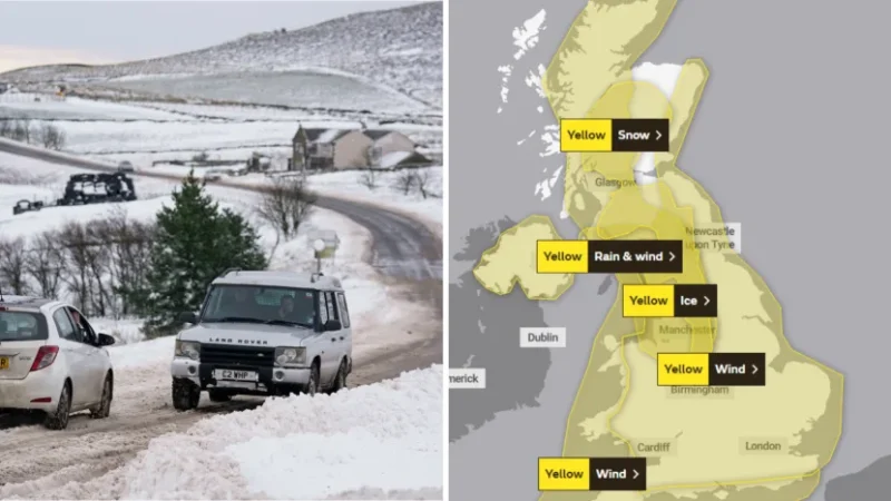
Storm Barra: Where in the UK will be hit and what weather warnings are in place?
Just over a week after Arwen battered parts of the UK, another storm is set to follow in its tracks.
Barra, the second named storm of the season, has been identified by the Met Office and yellow wind weather warnings have put in place as a result.
Will Barra be as damaging as Arwen and which areas will be hit?
When is Storm Barra due?
Barra will move in from the Atlantic on Tuesday, following on from wet and windy weather throughout Monday, the Met Office said.
⚠️ Yellow Weather Warning Issued ⚠️
Ice is likely across western Scotland and northwest England
2100 Monday until 0900 TuesdayLatest info 👉 https://t.co/QwDLMfRBfs
Stay #WeatherAware pic.twitter.com/531Ht6bSlj
— Met Office (@metoffice) December 6, 2021
Which areas will be affected?
While the west of Ireland will receive the worst of the storm, yellow wind warnings have been put in place across England, Wales and Northern Ireland.
The Met Office has also issued a new yellow warning for ice from 9pm on Monday until 9am on Tuesday across parts of western Scotland and north England.
Frank Saunders, a Chief Meteorologist at the Met Office, said strong winds arriving across the west through Tuesday morning “will spread inland and reach eastern areas through the afternoon and early evening”.
Additionally, a band of rain will turn to snow across northern England and Scotland on Tuesday.
As a result, yellow snow and ice warnings have been put in place in these areas.
For Northern Ireland, Met Eireann has issued a yellow warning for wind and rain for Antrim, Armagh, Down, Fermanagh, Tyrone and Derry, with strong winds and heavy rain bringing a risk of some travel disruption and flooding
#StormBarra set to bring widespread gales across western areas, with gusts of 70-80mph expected here.
Meanwhile, gusts 45-50mph are expected across eastern England@itvanglia | @itvnews | @itvweather pic.twitter.com/FYIQfZ6m7P
— Chris Page – Weatherman (@ChrisPage90) December 6, 2021
How strong will Barra be?
Gusts of 45-50 mph are expected widely, increasing to 60-70 mph in exposed coastal locations. In comparison, Storm Arwen lashed the UK with gusts of almost 100 miles per hour.
Barra’s strongest winds will ease across inland areas into the overnight period, the Met Office said.
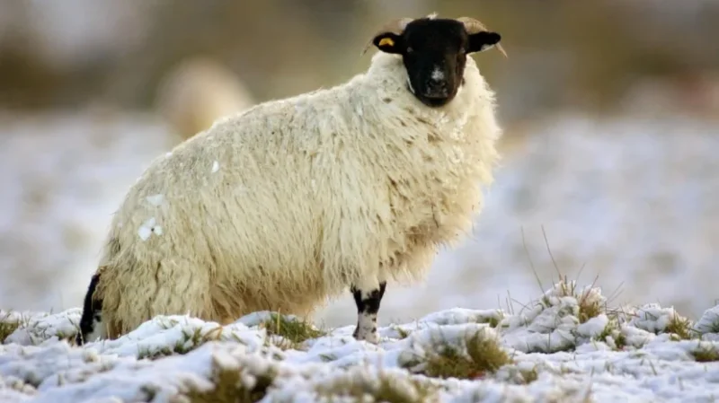
Two to five centimetres of snow is expected to accumulate fairly widely across the area in Scotland covered by the yellow snow warning.
“Locally this could reach 10cm, particularly in parts of the Southern Uplands and Highlands,” Deputy Chief Meteorologist Brent Walker said.
How will people be impacted?
Areas covered by snow and wind warnings should expected travel disruption, including possible road delays and train cancellations, the Met Office said.
It added that coastal communities covered by the wind warning will likely be affected by spray and large waves.
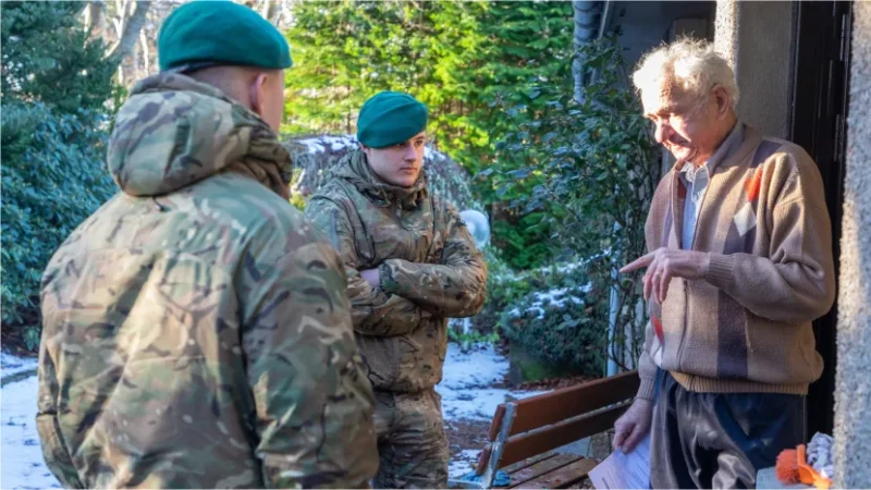
Barra comes ten days after Storm Arwen hit, causing disruption and affecting power supplies to around one million homes – still thousands of families have been left without power.
Credit: PA
Met Office meteorologist Simon Partridge warned that gale force winds of 45-50mph on Tuesday and into Wednesday would not make it “easier” for those trying to reconnect the remaining homes.
“It’s certainly not going to aid things with those sorts of wind strengths, and a mixture of rain and snow in there as well,” he said.
Have preparations been put in place to deal with Barra?
A spokesperson for the The Energy Networks Association said that operators were “working together” to prepare for the storm.
“We’re monitoring forecasts regularly, coordinating response plans and preparing to share resources if required,” he said.
How did Barra get its name?
The storm was named by Met Éireann the Irish equivalent of the Met Office.
The Met Office, Met Éireann and the Netherlands’ Meteorological institute, selected storm names for the 2021/22 season from the public’s suggestions./itv


")

